Road Routes on the SAP TM Map (with HERE Routing + custom BAdI)
This post walks through how we rendered actual road routes (not just straight lines) on the SAP TM Planning Cockpit map by enhancing the standard map objects with a custom BAdI and two external services:
- BAdI:
/SCMTMS/IF_MAP_ENHANCE_VB21 - Method:
ADJUST_NEW_OBJECTS - Service 1: Route calculation + polyline generation (HERE Routing v8)
- Service 2: Polyline decoding (custom service returning every point along the path)
Goal: inject the decoded route points into the
ROUTE_POINTSof each map link so that TM draws the exact road geometry between origins and destinations for FU/FO legs (stages).

What we built — in plain terms
- Intercept map rendering via
ADJUST_NEW_OBJECTS. - Call a routing API to get a polyline for each stage (origin/destination).
- Decode that polyline into a dense list of (latitude, longitude) points.
- Populate
ct_link_objects-ROUTE_POINTSwith those points (xpos = lon,ypos = lat). - Let TM draw the route with the real road shape in the Planning Cockpit.
Prerequisites
- SAP TM (S/4HANA) with Planning Cockpit map active.
- An API key for HERE Routing v8 (or any equivalent routing provider that returns polyline).
- Access to a polyline decoding service (we used our own HTTP endpoint described below).
- Basic knowledge of ABAP HTTP calls and JSON parsing.
1) BAdI hook: /SCMTMS/IF_MAP_ENHANCE_VB21 → ADJUST_NEW_OBJECTS
This enhancement point is called when the map objects are being created. In ADJUST_NEW_OBJECTS, you receive and can alter the collection ct_link_objects. Each link typically represents a connection between stops (stages) in FU/FO.

High level logic inside the method:
- Iterate over new link objects.
- Extract origin and destination coordinates TM already provides.
- Call Service 1 (routing) to get the polyline.
- Call Service 2 (decoder) to expand that polyline into coordinates.
- Replace the link’s
ROUTE_POINTSwith the decoded list.
2) Service 1 — Route calculation & polyline (HERE Routing v8)
HTTP (GET)
https://router.hereapi.com/v8/routes
  ?transportMode={VEHICLE_TYPE}
  &origin={ORIG_LAT},{ORIG_LON}
  &destination={DEST_LAT},{DEST_LON}
  &return=polyline,summary
&apikey={YOUR_APIKEY}transportMode: e.g.,car,truckorigin/destination: taken from TM’s stage coordinates- Response contains a polyline (HERE flexible polyline format)
We initially tried to decode in ABAP, but the math (precision + flexible polyline encoding) made it impractical without extra libraries. To guarantee fidelity at road scale, we opted for a dedicated decoding service.
3) Service 2 — Polyline decoding (custom API)
Endpoint (POST):
https://sdo.dev.api.portaldotransportador.com/api/swagger/#/Polyline/post_polyline_convertExample request body:
{
  "polyline": "{FLEXIBLE_POLYLINE_STRING}",
  "format": "here-flex"
}
Example response (simplified):
[
  { "index": 0, "lat": -23.51123, "lng": -46.62345 },
  { "index": 1, "lat": -23.51201, "lng": -46.62202 },
  ...
]
We then map each array element to a TM route point line.
In the front of application used (https://sdo.portaldotransportador.com), we can see all the usage of these polylines that have been generated:

4) ABAP: calling the services and injecting ROUTE_POINTS
Below is a compact pattern you can adapt. It uses /UI2/CL_JSON for JSON handling (available in modern S/4HANA). If your system differs, swap for your JSON utility of choice.
Tip: keep your API keys outside code (e.g., in SICF destinations, STRUST, or the Secure Store).
METHOD /scmtms/if_map_enhance_vb21~adjust_new_objects.
  DATA: lt_links         TYPE /scmtms/cl_ui_map_srv=>tt_map_link,  \"or relevant link type
        ls_link          LIKE LINE OF lt_links,
        lv_here_url      TYPE string,
        lv_polyline      TYPE string,
        lv_json          TYPE string,
        lt_points        TYPE STANDARD TABLE OF ty_point,          \"define ty_point: lat DEC16_8, lng DEC16_8, index INT4
        ls_point         TYPE ty_point.

  FIELD-SYMBOLS: <fs_link>         TYPE any,
                 <fs_route_points> TYPE any,   \"component table for ROUTE_POINTS
                 <fs_point>        TYPE any.

  \"Work on the links provided by TM:
  lt_links = ct_link_objects.

  LOOP AT lt_links ASSIGNING <fs_link>.
    \"1) Read origin/destination from the link (TM provides them during map build)
    \"   Replace these getters with the actual structure fields in your system:
    DATA(lv_orig_lat) = <fs_link>-from_lat.
    DATA(lv_orig_lon) = <fs_link>-from_lon.
    DATA(lv_dest_lat) = <fs_link>-to_lat.
    DATA(lv_dest_lon) = <fs_link>-to_lon.

    \"2) Build HERE Routing URL
    lv_here_url = |https://router.hereapi.com/v8/routes?transportMode=truck| &&
                  |&origin={ lv_orig_lat },{ lv_orig_lon }| &&
                  |&destination={ lv_dest_lat },{ lv_dest_lon }| &&
                  |&return=polyline,summary&apikey={ YOUR_APIKEY }|.

    \"3) Call HERE
    DATA(lv_here_response) = zcl_http_util=>get( lv_here_url ). \"Implement a simple GET helper (CL_HTTP_CLIENT)

    \"4) Parse HERE JSON to extract flexible polyline (adjust the path as per HERE response)
    DATA(ls_here) = /ui2/cl_json=>deserialize( json = lv_here_response ).
    \" Navigate to routes(1)->sections(1)->polyline, depending on provider’s schema:
    lv_polyline = zcl_json_nav=>get_string( ls_here
                     path = VALUE stringtab( ( 'routes[1]' ) ( 'sections[1]' ) ( 'polyline' ) ) ).

    \"5) Call Polyline Decoder service
    DATA(lv_body) = /ui2/cl_json=>serialize(
                       data = VALUE ty_decode_req( polyline = lv_polyline format = 'here-flex' ) ).
    DATA(lv_decode_resp) = zcl_http_util=>post_json(
                             url  = 'https://sdo.dev.api.portaldotransportador.com/api/polyline/convert'
                             body = lv_body ).

    \"6) Parse decoded points
    lt_points = /ui2/cl_json=>deserialize( json = lv_decode_resp ).

    \"7) Clear current route points and insert decoded ones
    \"   ROUTE_POINTS is a component of the link object; access it via field-symbols
    ASSIGN COMPONENT 'ROUTE_POINTS' OF STRUCTURE <fs_link> TO <fs_route_points>.
    IF <fs_route_points> IS ASSIGNED.
      DELETE <fs_route_points> WHERE xpos IS NOT INITIAL.

      LOOP AT lt_points INTO ls_point.
        APPEND INITIAL LINE TO <fs_route_points> ASSIGNING <fs_point>.
        ASSIGN COMPONENT 'XPOS' OF STRUCTURE <fs_point> TO FIELD-SYMBOL(<fs_x>).
        ASSIGN COMPONENT 'YPOS' OF STRUCTURE <fs_point> TO FIELD-SYMBOL(<fs_y>).

        \"IMPORTANT: X = longitude, Y = latitude
        <fs_x> = ls_point-lng.
        <fs_y> = ls_point-lat.
      ENDLOOP.
    ENDIF.
  ENDLOOP.

  \"Return the modified links to TM:
  ct_link_objects = lt_links.
ENDMETHOD.
And this is the tiny part that clears and fills ROUTE_POINTS—the heart of the rendering:
\" Delete current route points
DELETE <fs_link_objects>-route_points WHERE xpos IS NOT INITIAL.

LOOP AT ls_polyline_response-data-coordinates ASSIGNING FIELD-SYMBOL(<fs_coordinates>).

  \" Insert coordinates from polyline
  APPEND INITIAL LINE TO <fs_link_objects>-route_points ASSIGNING FIELD-SYMBOL(<fs_route_points>).
  <fs_route_points>-xpos = <fs_coordinates>-lng.
  <fs_route_points>-ypos = <fs_coordinates>-lat.

ENDLOOP.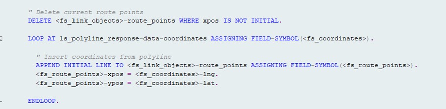
Why X=longitude and Y=latitude?
TM’s map model follows the common convention where x is horizontal (lon) and y is vertical (lat). Mixing them will flip or distort the route.
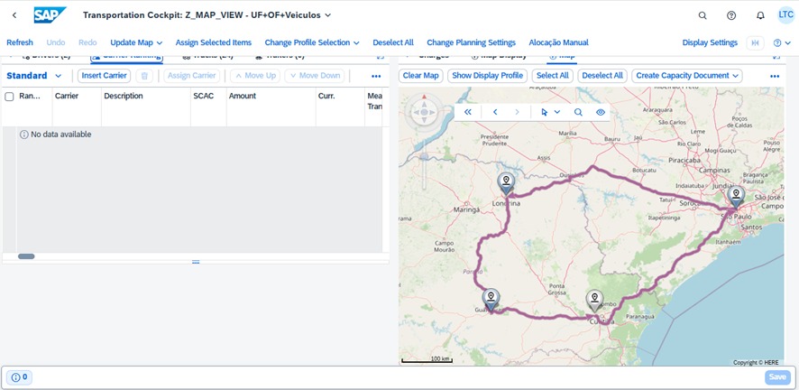
Testing in the Planning Cockpit
- Open your Map View profile in the Planning Cockpit.
- Load a scenario with FU/FO stages (at least two stops).
- When the map renders, the BAdI will:
- Call HERE,
- Decode the path,
- Insert the route points.
- You should now see road-accurate paths between each pair of stops.
Operational tips & gotchas
- Precision & density: if the decoded list is too sparse, the line may cut corners. Ensure the decoder returns all points (or resample as needed).
- Performance: Cache recent polylines by
(origin, destination, mode)to avoid repeated external calls while planning. - Error handling: If routing fails, fall back to the standard straight line so planners aren’t blocked.
- Security: Never hard-code API keys. Use secure storage and HTTPS only. Consider IP allowlists and quotas.
- Transport modes:
transportMode=truckvscaraffects the path (truck restrictions, tunnels, etc.). Match your TM planning context. - Coordinate order: HERE uses
lat,lon. TM expectsxpos = lon,ypos = lat. Be consistent at every step.
Minimal helpers (sketch)
CLASS zcl_http_util DEFINITION PUBLIC FINAL CREATE PUBLIC.
  PUBLIC SECTION.
    CLASS-METHODS get
      IMPORTING url TYPE string
      RETURNING VALUE(response) TYPE string.
    CLASS-METHODS post_json
      IMPORTING url TYPE string body TYPE string
      RETURNING VALUE(response) TYPE string.
ENDCLASS.

CLASS zcl_http_util IMPLEMENTATION.
  METHOD get.
    DATA(client) = NEW if_http_client( ).
    cl_http_client=>create_by_url( EXPORTING url = url IMPORTING client = client ).
    client->send( ).
    client->receive( ).
    response = client->response->get_data( ).
    client->close( ).
  ENDMETHOD.

  METHOD post_json.
    DATA(client) = NEW if_http_client( ).
    cl_http_client=>create_by_url( EXPORTING url = url IMPORTING client = client ).
    client->request->set_method( 'POST' ).
    client->request->set_content_type( 'application/json' ).
    client->request->set_cdata( body ).
    client->send( ).
    client->receive( ).
    response = client->response->get_data( ).
    client->close( ).
  ENDMETHOD.
ENDCLASS.
In production, replace the sketch with proper destinations (SM59), timeouts, retries, and error logging.
Troubleshooting checklist
- Route draws as a straight line
- Decoder failed or returned empty list. Log both service responses.
ROUTE_POINTSnot filled due to wrong component name or structure binding.- Route appears mirrored or shifted
- Lat/Lon flipped. Confirm
xpos = lon,ypos = lat. - Nothing shows up
- The BAdI implementation didn’t trigger (wrong enhancement spot or filters).
- Authorization/HTTP errors. Check ICM/SMICM logs and HTTP return codes.
- Performance issues
- Add caching on your side; batch requests when possible.
Takeaways
By enhancing the map objects via /SCMTMS/IF_MAP_ENHANCE_VB21→ADJUST_NEW_OBJECTS and combining a routing API with a polyline decoder, SAP TM can render true road geometry in the Planning Cockpit—hugely improving planner trust and usability.
